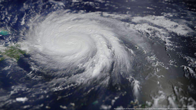
The devastating hurricanes hitting US territories this year served as a violent reminder of the vulnerability of many coastal communities, as well as the dire need to build up further protection and draw up preparedness plans.
A new study from the Centre for Advanced Infrastructure Technology (CAIT) at the University of Mississippi looked at Port of Miami and other at-risk ports around the world, to understand how they can prepare for tsunamis and rising sea levels. The research team used computer modelling and geospatial analysis of natural disaster risks to identify the priority measures that ports can take to build a comprehensive resilience management strategy.
“This is a very comprehensive study,” says Dr Waheed Uddin, lead researcher in the study. “To me, sea level rise isn’t of particular concern, since there is a very small chance of any city sinking due to sea level rise. It would take over 100 years to see any kind of significant sea level rise.”
However, coastal disasters such as hurricanes, tsunamis and extreme rainfall are of far more immediate concern. These phenomena can have devastating consequences not only on the port infrastructure, but also by disrupting trade and preventing emergency resources from reaching the affected areas further inland. After any natural disaster, ports and harbours must be opened as quickly as possible to facilitate recovery and reconstruction.
Following the Category 4 Hurricane Maria which hit Puerto Rico in October, reports emerged of shipping containers filled with emergency goods piling up at the Port of San Juan, unable to reach the rest of the island.
“We concluded that ports should focus on protection and resilience management against these most urgent threats,” Dr Uddin says. “If they can become resilient against these, it will provide adequate protection from rainfall and sea level rise [later on].”

US Tariffs are shifting - will you react or anticipate?
Don’t let policy changes catch you off guard. Stay proactive with real-time data and expert analysis.
By GlobalDataPorts as the first line of defence
This year’s hurricanes Harvey, Irma and Maria caused a trail of extensive devastation in their path and an enduring humanitarian crisis in their aftermath.
Hurricane Maria, considered to be the worst natural disaster on record in Dominica, affected Puerto Rico and many of its ports, including San Juan, Roseau and Pointe-à-Pitre.
Shortly after the storm passed, the National Oceanic and Atmospheric Administration’s (NOAA) Coast Guard teams travelled to some of these key ports to assess the damage and reconstruction efforts. Nearly three weeks in, emergency aid and food supplies were still battling bottlenecks in these ports. Rear Admiral Shepard Smith, director of the NOAA Office of Coast Survey, announced at the time that “the ports are currently unsafe for large ships, and it is necessary to restore Puerto Rico’s maritime commerce to make rebuilding possible.”
Similarly in Florida, Hurricane Irma left the state short of fuel, since it relies on its ports to bring in 90% of its fuel shipments.
Even after a port reopens, the work is far from done. During a hurricane, the shoreline can change significantly; marine debris may not have been detected in initial response surveys; and shoaling may have occurred in the approaches to ports. Survey work and chart updates need to continue, the Coast Guard warns.
In the study, Dr Uddin and his colleagues looked at the Port of Miami, as well as ports in the Gulf of Mexico and on the Mississippi Coast, Karachi Port in Pakistan and Hai Phong in Vietnam.
“There is no band-aid solution,” he says. “Firstly, ports have to look at the risks and conduct computer simulations, which will highlight which area of the port is under high risk of being submerged underwater.
“But the main way they can protect themselves is to make sure that all natural protection remains there and will not be jeopardised by development. That means areas of mangrove, similar to underwater forests, which reduce the effects of waves and tide. Plans need to be put in place not to destroy these through development.”
The worrying consequences of not protecting natural barriers can be observed in Pakistan’s Karachi Port, one of South Asia’s largest and busiest deep-water seaports, where intense commercial development in and around the area, as well as extreme over-fishing and untreated waste and oil spills, have destroyed the shoreline and its natural barriers, leaving the port particularly exposed should a natural disaster occur.
During a 2014 tsunami simulation organised by the United Nations, in which 24 countries including Pakistan took part, meteorologists found that Karachi could be “wiped out” in the event of a major earthquake in the Indian Ocean. In 1945, Karachi was hit by a tsunami that killed at least 4,000 people.
“Another protection is natural highland, which should also be protected against erosion, which can happen once development takes place. One of my students did some work in the Gulf of Mississippi port area, where there are beautiful beaches attracting tourism. Some of those highlands over the years got eroded and if a coastal disaster hits, those will immediately go under water.”
Can engineering pick up where nature was destroyed?
What happens in areas where these natural defences simply don’t exist, or have been already dilapidated? Can engineering step in?
The best lessons come from the Netherlands, where much of country’s land sits below sea level. Here, ports have come up with inventive engineering solutions in response to the constant threat of flooring during high tide.
First, the Dutch combat their topographic challenges by building dikes and complex dams, complete with interconnected walls and hollow gates that can open, float, or be completely removed. While the gates allow fish to swim freely when the sea is calm, they quickly fill up with water in the event of a sudden water surge, become heavy and sink, forming a naturally fortified dam.
Another innovation in coastal protection is the Sand Engine project, installed in the Netherlands in 2011, which saw a large amount of sand piled up along the coast of South Holland to act as a natural barrier against flooding. In August this year, Royal HaskoningDHV designed a second, smaller ‘sand engine’ to halt erosion along the Norfolk coastline in the UK.
With global warming expected to bring about fast sea level rise, but also increase the frequency, intensity and duration of extreme weather events affecting vulnerable ports and the communities relying on them, experts strongly advise that port authorities invest in building up resilience today.
“We call this hardening of infrastructure,” says Dr Uddin. “Whatever the cost of this investment, it is justified. If, on the other hand, ports are not prepared, the cost of these disasters can be tremendous.”


